
Garmin aera 760 Aviation GPS Review for Pilots
See why the Garmin aera 760 remains a serious portable aviation GPS with a 7-inch display, charts, Connext, traffic integration and dedicated cockpit hardware.

A Dedicated Aviation GPS Still Makes Sense in the Age of the iPad
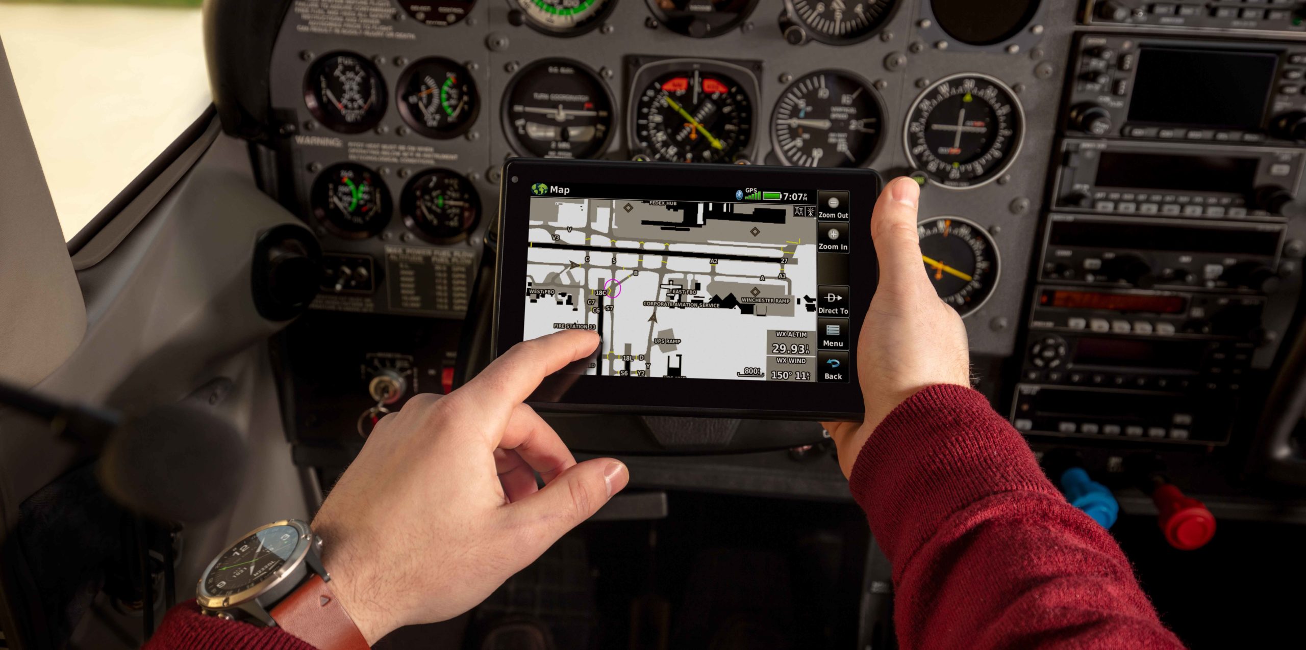
Tablets have transformed general aviation, but they have not eliminated the case for a dedicated cockpit GPS. The Garmin aera 760 is built specifically for aviation, with a bright 7-inch touchscreen, aviation charts, flight planning, terrain awareness, dedicated GPS hardware and integration with other Garmin avionics.
The Garmin aera 760 Aviation GPS available through Amazon is aimed at pilots who want more than another consumer tablet mounted in the cockpit.
Its appeal is particularly strong for aircraft owners, frequent general aviation pilots and operators already using Garmin equipment. The aera 760 can communicate with compatible traffic and weather receivers, avionics, radios and flight-planning systems while remaining portable enough to move between aircraft.
It is not an IFR-certified navigator and should not be treated as one. Its value is as a powerful portable aviation display and situational-awareness tool that can become substantially more capable when connected to the rest of a Garmin cockpit.
Quick Verdict
The aera 760 makes the strongest case for pilots who want dedicated aviation hardware rather than relying entirely on a tablet.
Its 7-inch sunlight-readable display, GPS/GLONASS receiver, flight-plan capabilities, geo-referenced charts and avionics integration make it much closer to a portable multifunction display than a basic handheld GPS.
If you already fly with compatible Garmin avionics, a GTX 345, GDL 52, Flight Stream or Garmin NAV/COM equipment, the value proposition becomes considerably stronger.
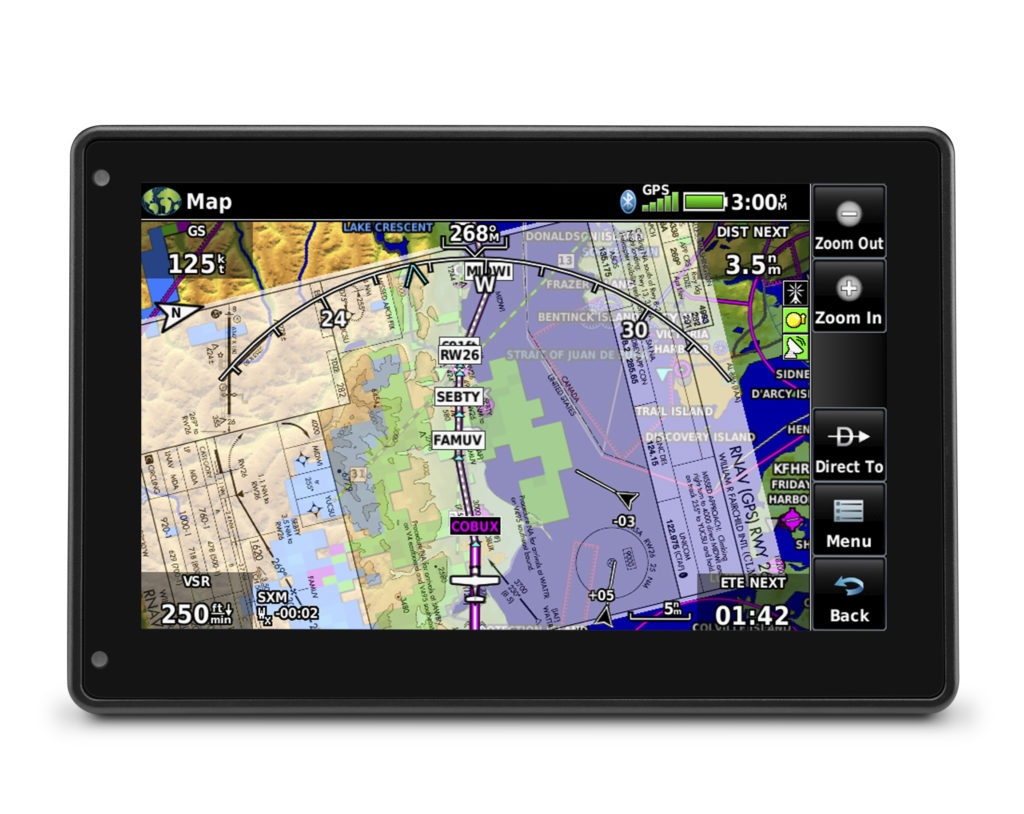
Garmin aera 760
7-inch Touchscreen · WAAS GPS + GLONASS · Wi-Fi · Bluetooth · USB-C · Garmin Connext
Display
7 Inches
Battery
Up to 4 Hours
Weight
19.8 oz
Receiver
WAAS GPS + GLONASS
Why Buy a Dedicated Aviation GPS Instead of Another Tablet?
An iPad running a good electronic flight bag application is capable of an enormous amount. For many pilots, it remains an essential cockpit tool.
The aera 760 attacks a different problem. Garmin built the device around aviation use rather than adapting a consumer computing platform to the cockpit.
Garmin specifically highlights screen visibility in bright cockpits, resistance to overheating and the ability to create stable hard-wired connections to other aircraft equipment as advantages over conventional tablets.
For a pilot flying rental aircraft a few times per month, a tablet may remain the simpler answer. For an aircraft owner building a semi-integrated portable avionics setup, the aera 760 offers capabilities a conventional tablet cannot duplicate as neatly.
The 7-Inch Screen Is the Center of the Product
The aera 760 uses a bright 7-inch touchscreen designed to remain readable in cockpit lighting conditions.
The larger display provides noticeably more room for charts, terrain, traffic and flight-plan information than Garmin's smaller aera 660.
Garmin's interface also resembles the company's GTN Xi, G3X Touch and Garmin Pilot environments. Pilots already familiar with the Garmin ecosystem should therefore face less of a learning curve.
The device measures approximately 7.29 inches wide, 4.85 inches high and 0.91 inches deep, with a published weight of 19.8 ounces including the battery.
Installation Detail
Power the Display Properly if You Want Maximum Brightness
Garmin notes that the aera 760 achieves maximum display brightness when powered through the appropriate cradle or a suitable USB-C power source.
Garmin specifically warns that some USB-A to USB-C power arrangements can limit available display brightness. Pilots planning a permanent or semi-permanent cockpit installation should therefore think about power delivery rather than simply attaching the unit to any available USB socket.
The aera 760 Can Carry Much More Than a Direct-To Flight Plan
Earlier portable GPS units were often little more than moving maps with Direct-To functionality.
The aera 760 can load departures, arrivals and complete instrument approach procedures into a flight plan. It also supports victor airways, user-defined holds and holds over existing navigation fixes.
IFR enroute charts, VFR sectionals and Garmin FliteCharts can be geo-referenced, allowing the aircraft position to appear directly on the chart.
Compatible Jeppesen electronic charts provide an additional route for pilots requiring worldwide instrument approach chart coverage.
Approaches can also be displayed over the moving map, giving the pilot another way to visualize how a procedure relates to surrounding terrain and the aircraft's current position.
Important Limitation
Being Able to Display an Approach Does Not Make the aera 760 an IFR Navigator
Garmin explicitly states that the aera 760 is not IFR certified. It is a portable device and is not intended to replace an approved TSO or PMA IFR navigator.
Even though the unit can load complete approach procedures, that functionality should be treated as enhanced situational awareness rather than authorization to use the portable GPS as the primary certified source for IFR navigation.
Add a Compatible Receiver and the aera 760 Becomes Far More Capable
Built-in Bluetooth allows the aera 760 to receive additional aviation information from compatible Garmin products.
Pair it with equipment such as a Garmin GTX 345 or GDL 52 and the display can show ADS-B traffic, FIS-B weather and other information depending on the connected equipment.
With a compatible GDL 52 and the appropriate subscription, SiriusXM aviation weather can also be displayed.
Garmin's TargetTrend feature helps pilots judge the direction and closure trend of nearby traffic, while TerminalTraffic can provide a more detailed picture of participating aircraft and ground traffic around supported airport environments.
These integrations are one of the main reasons to look at the aera 760 as part of a cockpit ecosystem rather than as a standalone GPS purchase.
Wi-Fi Makes Database Updates Less Painful
The aera 760 includes built-in Wi-Fi in addition to Bluetooth.
When connected to Wi-Fi, the unit can download aviation database and software updates without needing to be physically attached to a computer.
Pilots can also review worldwide weather information through an internet connection before departure.
The Strongest Reason to Buy One May Be Sitting Elsewhere in Your Panel
The aera 760 becomes much more interesting when an aircraft already contains compatible Garmin avionics.
Aircraft equipped with GNS 430W or GNS 530W navigators can transfer flight-plan data to the aera 760 through an appropriate hard-wired connection.
Flight Stream 210 or 510 can provide compatible wireless connectivity with those navigators.
When connected to compatible Garmin NAV/COM equipment such as the GTR 225, GNC 255 or GTR 200, the aera can transfer frequencies and airport identifiers to the radio.
That kind of integration is difficult to evaluate from the GPS specification sheet alone. For an aircraft owner already invested in Garmin equipment, it can be the difference between buying another screen and buying a genuinely useful extension of the installed avionics.
Aircraft Owners
A Portable GPS Does Not Have to Remain Completely Wireless
Garmin supports hard-wired power, audio and dual RS-232 connections for the aera 760. Depending on installed equipment, RS-232 connectivity can provide a more stable link and exchange useful information with radios, approved navigators, autopilots and other compatible equipment.
Select VFR Autopilot Integration Is Possible
Garmin says the aera 760 can connect to select autopilots for lateral GPS guidance and single-point VNAV guidance during visual operations.
One example given by Garmin is using VNAV from the aircraft's present altitude down toward pattern altitude while connected to a compatible autopilot.
Installation compatibility matters here. Pilots should verify their specific avionics and aircraft installation rather than assuming the portable can interface with every autopilot.
3D Vision Adds Another Way to Understand the Terrain Around You
Garmin's 3D Vision presents surrounding terrain, obstacles and airports from a three-dimensional perspective rather than requiring the pilot to interpret everything from a conventional top-down chart.
The unit can also display an HSI with lateral and vertical deviation information.
When properly configured with attitude information, the aera 760 can provide synthetic-vision functionality and backup attitude information.
These tools enhance awareness. They do not change the portable nature of the equipment or convert the unit into a substitute for required certified primary flight instrumentation.
Garmin Included Several Useful Preflight Tools
The aera 760 is not limited to mapping.
It includes an E6B flight computer, weight and balance calculations and fuel-price information.
The E6B function can calculate items including estimated fuel burn and estimated arrival time before departure. During flight, current groundspeed can be used to update fuel-burn and ETA calculations.
A built-in PDF viewer also allows pilots to carry additional documents on the unit using files transferred through microSD.
Helicopter Pilots Get a Feature Most Fixed-Wing Buyers Will Never Use
Garmin includes WireAware functionality for helicopter operations.
WireAware can overlay known power-line locations and relative altitude information on the moving map while providing visual and aural proximity alerts.
As with other terrain and obstacle databases, pilots should treat the information as situational-awareness support rather than assume every obstacle or wire is contained in the database.
Garmin aera 760 Key Specifications
| Specification | Garmin aera 760 |
|---|---|
| Display | 7-inch diagonal touchscreen |
| GPS receiver | High-sensitivity WAAS GPS + GLONASS |
| Battery life | Up to 4 hours nominal |
| Dimensions | 7.29 × 4.85 × 0.91 inches |
| Weight | 19.8 oz with battery |
| Waypoints | Up to 3,000 |
| Routes | 50 routes, up to 300 points each |
| Wireless | Wi-Fi and Bluetooth |
| Charging | USB-C / compatible aircraft power |
| IFR certified navigator | No |
Who Should Buy the Garmin aera 760?
Aircraft Owners
Owners can take better advantage of hard-wired power, RS-232 connectivity and integration with installed avionics.
Garmin Cockpit Users
Existing Garmin navigators, radios, traffic receivers and Flight Stream equipment can substantially increase the unit's usefulness.
Frequent GA Pilots
Pilots who fly enough to care about dedicated hardware, heat resistance and sunlight readability have a stronger case than occasional renters.
Helicopter Operators
WireAware and aviation-specific terrain functionality add capabilities directed specifically at rotary-wing operations.
Who Probably Does Not Need One?
A new student pilot already carrying a modern tablet may find the aera 760 difficult to justify immediately.
The same applies to occasional renters who cannot integrate the unit with the aircraft and primarily need charts, weather briefing and basic GPS position.
The aera 760 earns its price through dedicated hardware and integration. If you are unlikely to use those advantages, a tablet-based electronic flight bag may remain sufficient.
What We Like and What Buyers Should Consider
Reasons to Buy
- Large 7-inch aviation-focused display.
- Dedicated WAAS GPS and GLONASS receiver.
- Geo-referenced IFR and VFR charts.
- Full procedure loading and flight planning.
- ADS-B traffic and weather integration with compatible equipment.
- Garmin Connext ecosystem.
- Hard-wired integration possibilities.
- 3D Vision and synthetic-vision capability.
- Wi-Fi database updates.
- Built specifically for cockpit conditions.
Reasons to Think Twice
- It is considerably more expensive than simply using an existing tablet.
- Battery life is only up to about four hours without external power.
- It is not an IFR-certified navigator.
- Some of its strongest features require additional Garmin equipment.
- Chart and database updates can create ongoing costs.
- Maximum display performance depends on providing appropriate power.
Garmin aera 760 Aviation GPS
A dedicated 7-inch portable aviation navigator with GPS/GLONASS, charts, flight planning, Wi-Fi, Bluetooth and compatibility with selected Garmin avionics.
View Garmin aera 760 on AmazonAmazon pricing and availability can change at any time.
The aera 760 Makes the Most Sense as Part of a Garmin Cockpit
On its own, the Garmin aera 760 is a capable portable GPS with a large display, excellent aviation mapping and considerably more flight-planning functionality than the handheld navigators of the past.
Its strongest argument appears when the aircraft already contains compatible Garmin equipment. Traffic, weather, flight-plan exchange, NAV/COM integration and hard-wired connections turn the portable into a useful extension of the existing panel.
Pilots who simply need another moving map may be better served by the tablet they already own. Pilots who want dedicated aviation hardware designed around the cockpit should take the aera 760 much more seriously.
Check the Current Garmin aera 760 Price
Compare the current Amazon offer with Garmin and specialist aviation retailers before purchasing, and confirm compatibility with any avionics you intend to connect.
Check Garmin aera 760 on AmazonGarmin aera 760 FAQ
Is the Garmin aera 760 IFR certified?
No. Garmin explicitly states that the aera 760 is not an IFR-certified navigator. It can display and load instrument procedures for situational awareness but does not replace an approved IFR navigator.
How large is the Garmin aera 760 screen?
The aera 760 uses a 7-inch diagonal touchscreen designed for cockpit use and sunlight readability.
How long does the Garmin aera 760 battery last?
Garmin specifies up to approximately four hours of nominal battery life depending on screen backlight and connectivity use.
Can the aera 760 display ADS-B traffic?
Yes, when connected to compatible Garmin equipment such as a GTX 345 or GDL 52. The exact traffic and weather information available depends on the connected receiver and service.
Does the Garmin aera 760 have Wi-Fi?
Yes. Wi-Fi can be used for compatible software and aviation database updates and for viewing online weather information before departure.
Is an aera 760 better than an iPad?
It depends on the mission. An iPad offers broader general-purpose functionality and many excellent aviation apps. The aera 760 offers dedicated aviation hardware, a sunlight-oriented display, lower overheating risk and integration with selected installed avionics.
Can the aera 760 show instrument approaches?
Yes. The device can load complete approaches, departures and arrivals and can display compatible geo-referenced charts. This does not make it an IFR-certified navigation source.